
Thank you for supporting this site ❤️
Make a donation
Make a donation
Gear up for your next adventure:
As an Amazon Associate, this site earns from qualifying purchases at no extra cost to you.
Dolmar topographic map
Click on the map to display elevation.
Thank you for supporting this site ❤️
Make a donation
Make a donation
Gear up for your next adventure:
As an Amazon Associate, this site earns from qualifying purchases at no extra cost to you.
Dolmar
1668 ließ Herzog Moritz von Sachsen-Zeitz etwa 400 m nordwestlich des Berggipfels auf 737,8 m Höhe ein herzogliches Jagdhaus (Jagdschloss) erbauen, das 1726 durch ein Feuer nach Blitzschlag zerstört wurde.
Thank you for supporting this site ❤️
Make a donation
Make a donation
Gear up for your next adventure:
As an Amazon Associate, this site earns from qualifying purchases at no extra cost to you.
About this map
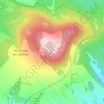
Name: Dolmar topographic map, elevation, terrain.
Average elevation: 566 m
Minimum elevation: 417 m
Maximum elevation: 737 m
Thank you for supporting this site ❤️
Make a donation
Make a donation
Gear up for your next adventure:
As an Amazon Associate, this site earns from qualifying purchases at no extra cost to you.