Geolocate

Tempuran topographic map

Click on the map to display elevation.

About this map

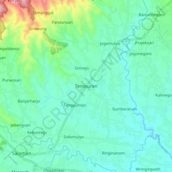
Name: Tempuran topographic map, elevation, terrain.

Location: Tempuran, Magelang, Central Java, Java, 56161, Indonesia (-7.58906 110.12128 -7.50906 110.20128)

Average elevation: 304 m

Minimum elevation: 234 m

Maximum elevation: 582 m

Other topographic maps

Click on a map to view its topography, its elevation and its terrain.

Salam

Indonesia > Central Java > Magelang

Average elevation: 284 m

Muntilan

Indonesia > Central Java > Magelang

Average elevation: 296 m

Ngablak

Indonesia > Central Java > Magelang

Average elevation: 629 m

Kaliurang

Indonesia > Central Java > Magelang

Average elevation: 768 m

Kaliurang

Indonesia > Central Java > Magelang

Average elevation: 768 m

Gear up for your next adventure:

🚲Handlebar Phone Mount - View topographic-map.com live while cycling
🧰Multitool Knife - Compact and versatile tool for outdoor use
🥾Light Trekking Boots - Supportive boots for multi-day treks
Camping Coffee Maker - Brew fresh coffee anywhere on the topographic map
🥾Durable Hiking Shoes - Long-lasting shoes for frequent hiking

As an Amazon Associate, this site earns from qualifying purchases at no extra cost to you.