Geolocate

Griffith Park topographic map

Click on the map to display elevation.

About this map

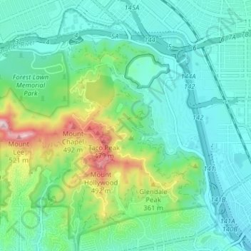
Name: Griffith Park topographic map, elevation, terrain.

Location: Griffith Park, Los Angeles, California, United States (34.11231 -118.32900 34.16145 -118.26550)

Average elevation: 211 m

Minimum elevation: 112 m

Maximum elevation: 533 m

Other topographic maps

Click on a map to view its topography, its elevation and its terrain.

Gear up for your next adventure:

Camping Groundsheet - Protect your tent from moisture and dirt
🥾Mountain Trail Shoes - High-traction shoes for mountain trails
🥾Waterproof Hiking Boots - Boots keeping your feet dry in wet conditions
🚲Bike Repair Kit - Essential tools for on-trail mechanical issues
💡LED Camping Lantern - Illuminate your campsite with long-lasting lanterns

As an Amazon Associate, this site earns from qualifying purchases at no extra cost to you.