Geolocate

Chenappady topographic map

Click on the map to display elevation.

About this map

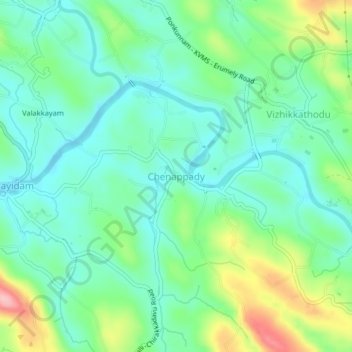
Name: Chenappady topographic map, elevation, terrain.

Location: Chenappady, Kanjirappally, Kottayam, Kerala, 686520, India (9.48638 76.77655 9.52638 76.81655)

Average elevation: 64 m

Minimum elevation: 19 m

Maximum elevation: 175 m

Gear up for your next adventure:

🧥Fleece Jacket - Warm and lightweight jacket for layering
Tent Footprint - Protect tent floor and increase durability
🥾Light Trekking Boots - Supportive boots for multi-day treks
🧶550 Survival Paracord - Versatile utility cord for emergency repairs and rigging
🧥Softshell Jacket - Windproof and breathable jacket for hiking

As an Amazon Associate, this site earns from qualifying purchases at no extra cost to you.