
Make a donation
Gear up for your next adventure:
As an Amazon Associate, this site earns from qualifying purchases at no extra cost to you.
Carballeda de Avia topographic map
Click on the map to display elevation.
Make a donation
Gear up for your next adventure:
As an Amazon Associate, this site earns from qualifying purchases at no extra cost to you.
Carballeda de Avia
Carballeda de Avia is a municipality in the province of Ourense, in the autonomous community of Galicia, Spain. It belongs to the comarca of O Ribeiro. It is located to the west of the province, 5.7 kilometres (3.5 mi) northwest of Ribadavia off the A-52 road. As of 2012 it had a population of 1487 people. It is a wine-producing area with about 3000 hectares dedicated to vineyards, some of which are at an altitude of 479 metres (1,572 ft). River valleys in the municipality include the Miño, Avia, Arnoia and Barbantiño.
Make a donation
Gear up for your next adventure:
As an Amazon Associate, this site earns from qualifying purchases at no extra cost to you.
About this map
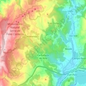
Name: Carballeda de Avia topographic map, elevation, terrain.
Location: Carballeda de Avia, O Ribeiro, Ourense, Galicia, Spain (42.29323 -8.26196 42.37769 -8.13624)
Average elevation: 346 m
Minimum elevation: 69 m
Maximum elevation: 827 m
Make a donation
Gear up for your next adventure:
As an Amazon Associate, this site earns from qualifying purchases at no extra cost to you.
Other topographic maps
Click on a map to view its topography, its elevation and its terrain.