
Make a donation
Gear up for your next adventure:
As an Amazon Associate, this site earns from qualifying purchases at no extra cost to you.
Lavant topographic map
Click on the map to display elevation.
Make a donation
Gear up for your next adventure:
As an Amazon Associate, this site earns from qualifying purchases at no extra cost to you.
About this map
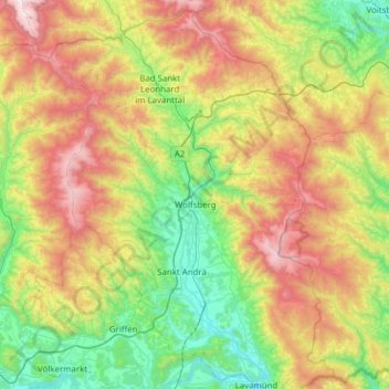
Name: Lavant topographic map, elevation, terrain.
Location: Lavant, Bezirk Wolfsberg, Carinthia, Austria (46.63878 14.57275 47.06066 14.95818)
Average elevation: 1,025 m
Minimum elevation: 344 m
Maximum elevation: 2,270 m
Make a donation
Gear up for your next adventure:
As an Amazon Associate, this site earns from qualifying purchases at no extra cost to you.
Other topographic maps
Click on a map to view its topography, its elevation and its terrain.
Hintergumitsch
Austria > Carinthia > Bezirk Wolfsberg > Frantschach-Sankt Gertraud
Average elevation: 662 m
Schiefling
Austria > Carinthia > Bezirk Wolfsberg > Bad Sankt Leonhard im Lavanttal
Average elevation: 849 m
Wartkogel
Austria > Carinthia > Bezirk Wolfsberg > Bad Sankt Leonhard im Lavanttal
Average elevation: 964 m
Make a donation
Gear up for your next adventure:
As an Amazon Associate, this site earns from qualifying purchases at no extra cost to you.