Geolocate

Doyang topographic map

Click on the map to display elevation.

About this map

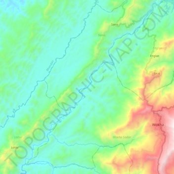
Name: Doyang topographic map, elevation, terrain.

Location: Doyang, Sanis, Wokha, Nagaland, 797100, India (26.04235 94.08844 26.23241 94.26201)

Average elevation: 552 m

Minimum elevation: 169 m

Maximum elevation: 1,794 m

Gear up for your next adventure:

🧥Thermal Layer - Insulating layer for cold outdoor conditions
🥤Collapsible Travel Cup - Saves space and weight in your mess kit
🎒Hiking Backpack - Lightweight and ergonomic backpacks for day hikes or multi-day treks
🧢Beanie Hat - Keep your head warm in cold weather
🧢Outdoor Visor - Breathable visor for sunny hikes

As an Amazon Associate, this site earns from qualifying purchases at no extra cost to you.