Geolocate

Mayfield topographic map

Click on the map to display elevation.

About this map

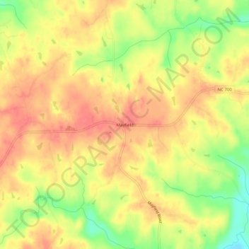
Name: Mayfield topographic map, elevation, terrain.

Location: Mayfield, Rockingham County, North Carolina, United States (36.49125 -79.58669 36.53125 -79.54669)

Average elevation: 186 m

Minimum elevation: 145 m

Maximum elevation: 209 m

Other topographic maps

Click on a map to view its topography, its elevation and its terrain.

Eden

United States > North Carolina > Rockingham County

Average elevation: 191 m

Eden

United States > North Carolina > Rockingham County

Average elevation: 191 m

Eden

United States > North Carolina > Rockingham County

Average elevation: 191 m

Eden

United States > North Carolina > Rockingham County

Average elevation: 191 m

Gear up for your next adventure:

🧢Sun Hat - Wide-brim hat for sun protection
Backpacking Tent - Lightweight tent for long-distance hiking trips
🧢Beanie Hat - Keep your head warm in cold weather
🔋Lithium AA Batteries - Long-lasting power that performs in extreme cold
🧢Hiking Hat - Sun-protective and breathable hats for long treks

As an Amazon Associate, this site earns from qualifying purchases at no extra cost to you.