
Make a donation
Gear up for your next adventure:
As an Amazon Associate, this site earns from qualifying purchases at no extra cost to you.
Creekside Village topographic map
Click on the map to display elevation.
Make a donation
Gear up for your next adventure:
As an Amazon Associate, this site earns from qualifying purchases at no extra cost to you.
About this map
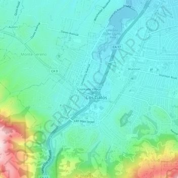
Name: Creekside Village topographic map, elevation, terrain.
Average elevation: 166 m
Minimum elevation: 79 m
Maximum elevation: 486 m
Make a donation
Gear up for your next adventure:
As an Amazon Associate, this site earns from qualifying purchases at no extra cost to you.
Other topographic maps
Click on a map to view its topography, its elevation and its terrain.
Vasona Lake County Park
United States > California > Santa Clara County > Los Gatos > Shannon
Average elevation: 109 m
Lexington Reservoir County Park
United States > California > Santa Clara County > Los Gatos
The reservoir is in the foothills of the Santa Cruz Mountains, at an elevation of 645 feet (197 m).
Average elevation: 330 m