Geolocate

Orsay topographic map

Click on the map to display elevation.

About this map

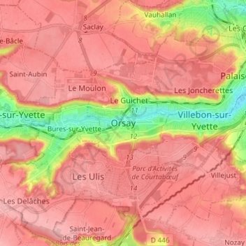
Name: Orsay topographic map, elevation, terrain.

Location: Orsay, Palaiseau, Essonne, France métropolitaine, 91400, France (48.65918 2.14746 48.73918 2.22746)

Average elevation: 136 m

Minimum elevation: 50 m

Maximum elevation: 176 m

Gear up for your next adventure:

🥾Mountain Hiking Shoes - Shoes with superior grip for mountainous terrain
💡LED Camping Lantern - Illuminate your campsite with long-lasting lanterns
🧣Evaporative Cooling Towel - Beat the heat during intense summer climbs
Family Camping Tent - Spacious tent suitable for family camping trips
🧥Softshell Jacket - Windproof and breathable jacket for hiking

As an Amazon Associate, this site earns from qualifying purchases at no extra cost to you.