
Make a donation
Gear up for your next adventure:
As an Amazon Associate, this site earns from qualifying purchases at no extra cost to you.
Mill Creek Point topographic map
Click on the map to display elevation.
Make a donation
Gear up for your next adventure:
As an Amazon Associate, this site earns from qualifying purchases at no extra cost to you.
About this map
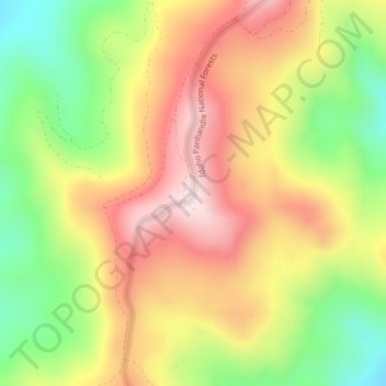
Name: Mill Creek Point topographic map, elevation, terrain.
Average elevation: 1,275 m
Minimum elevation: 1,038 m
Maximum elevation: 1,498 m
Make a donation
Gear up for your next adventure:
As an Amazon Associate, this site earns from qualifying purchases at no extra cost to you.
Other topographic maps
Click on a map to view its topography, its elevation and its terrain.
Ione
United States > Washington > Pend Oreille County
Ione is situated on the west bank of the Pend Oreille River as it flows north towards Canada. Big Muddy Creek, Little Muddy Creek and Cedar Creek, from south to north, join the river in Ione. State Route 31 passes through town. Ione Bridge, on the southern edge of town, is the only road crossing of the Pend…
Average elevation: 670 m
Newport
United States > Washington > Pend Oreille County
Newport is located at an elevation of 2,160 feet (658.5 m) and according to the United States Census Bureau, the city has a total area of 1.07 square miles (2.77 km2), all of it land.
Average elevation: 662 m
Kalispel Reservation
United States > Washington > Pend Oreille County > Airway Heights
Average elevation: 801 m
Ione
United States > Washington > Pend Oreille County
Ione is situated on the west bank of the Pend Oreille River as it flows north towards Canada. Big Muddy Creek, Little Muddy Creek and Cedar Creek, from south to north, join the river in Ione. State Route 31 passes through town. Ione Bridge, on the southern edge of town, is the only road crossing of the Pend…
Average elevation: 670 m
Make a donation
Gear up for your next adventure:
As an Amazon Associate, this site earns from qualifying purchases at no extra cost to you.
Newport
United States > Washington > Pend Oreille County
Newport is located at an elevation of 2,160 feet (658.5 m) and according to the United States Census Bureau, the city has a total area of 1.07 square miles (2.77 km2), all of it land.
Average elevation: 662 m
Make a donation
Gear up for your next adventure:
As an Amazon Associate, this site earns from qualifying purchases at no extra cost to you.