
Make a donation
Gear up for your next adventure:
As an Amazon Associate, this site earns from qualifying purchases at no extra cost to you.
Puy de Vichatel topographic map
Click on the map to display elevation.
Make a donation
Gear up for your next adventure:
As an Amazon Associate, this site earns from qualifying purchases at no extra cost to you.
About this map
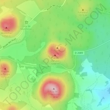
Name: Puy de Vichatel topographic map, elevation, terrain.
Average elevation: 967 m
Minimum elevation: 869 m
Maximum elevation: 1,115 m
Make a donation
Gear up for your next adventure:
As an Amazon Associate, this site earns from qualifying purchases at no extra cost to you.
Other topographic maps
Click on a map to view its topography, its elevation and its terrain.
Lac de la Cassière
France > Auvergne-Rhône-Alpes > Puy-de-Dôme > Aydat > La Cassière
Le lac de la Cassière se situe sur la commune d'Aydat, à côté du village de La Cassière, à environ 17 kilomètres de Clermont-Ferrand. Le lac de la Cassière est situé à 861 mètres d'altitude.
Average elevation: 911 m