

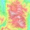
Lao topographic map
Click on the map to display elevation.
Lao
The river has a length of 51 km. Its source is near the Serra del Prete mountain in the Pollino massif, at an altitude of 2,181 meters. Here it flows to the west through the Valley of Mercure and passes Viggianello. Later it changes course to southwest and passes Laino Borgo and Papasidero. Near Orsomarso it is joined by the Argentino from the left, its main tributary. It empties in the Tyrrhenian Sea near Scalea. It has a drainage basin of 594 square kilometres (229 sq mi).
About this map

Name: Lao topographic map, elevation, terrain.
Location: Lao, Cosenza, Calabria, Italy (39.77617 15.79432 39.97999 16.05817)
Average elevation: 621 m
Minimum elevation: -1 m
Maximum elevation: 1,619 m
Other topographic maps
Click on a map to view its topography, its elevation and its terrain.



Trenta
Trenta is a town high in the Crati river Valley. The town's ancient name, Triginta, derives from the Latin number triginta or thirty. Trenta was founded by Cosentine refugees in the 10th century AD, in the era of Saracen occupations of the nearby capital, Magli, which eventually became one of the…
Average elevation: 560 m