Geolocate

Adana topographic map

Click on the map to display elevation.

About this map

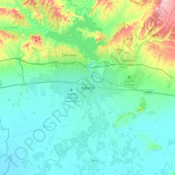
Name: Adana topographic map, elevation, terrain.

Location: Adana, Seyhan, Adana, Mediterranean Region, 01060, Turkey (36.82636 35.16529 37.14636 35.48529)

Average elevation: 61 m

Minimum elevation: 3 m

Maximum elevation: 312 m

Other topographic maps

Click on a map to view its topography, its elevation and its terrain.

01020

Turkey > Seyhan

Average elevation: 25 m

Bahçeşehir Mahallesi

Turkey > Seyhan

Average elevation: 73 m

Gear up for your next adventure:

🦯Trekking Poles - Reduced impact on joints for steep topographic climbs
🥫Freeze-Dried Meals - Lightweight, high-calorie nutrition for multi-day treks
🧦Hiking Socks - Moisture-wicking and comfortable socks for long hikes
🧦Hiking Liner Socks - Thin base layer to prevent friction and blisters
🧢Sun Protection Cap - Breathable cap to protect from sun exposure

As an Amazon Associate, this site earns from qualifying purchases at no extra cost to you.