Geolocate

Kayapa topographic map

Click on the map to display elevation.

About this map

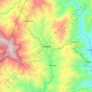
Name: Kayapa topographic map, elevation, terrain.

Location: Kayapa, Nueva Vizcaya, Cagayan Valley, Philippines (16.31806 120.84716 16.39806 120.92716)

Average elevation: 1,259 m

Minimum elevation: 636 m

Maximum elevation: 2,008 m

Other topographic maps

Click on a map to view its topography, its elevation and its terrain.

Kasibu River

Philippines > Nueva Vizcaya > Kasibu

Average elevation: 866 m

Kayapa

Philippines > Nueva Vizcaya

Average elevation: 1,258 m

Gear up for your next adventure:

🧣Merino Neck Gaiter - Protects against wind, sun, and cold at high altitudes
🥾Trekking Boots - Durable boots for long-distance trekking
🧦Merino Wool Socks - Moisture-wicking comfort for long-distance hiking
🚲MTB Frame Bag - Carry tools and maps directly on your bicycle frame
🧥Softshell Jacket - Windproof and breathable jacket for hiking

As an Amazon Associate, this site earns from qualifying purchases at no extra cost to you.