Geolocate

Dokkum topographic map

Click on the map to display elevation.

About this map

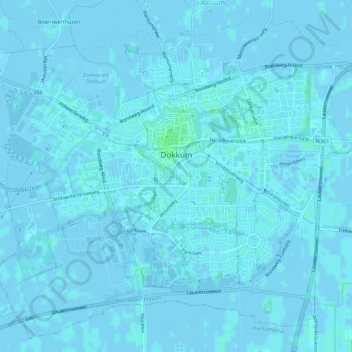
Name: Dokkum topographic map, elevation, terrain.

Location: Dokkum, Noardeast-Fryslân, Frisia, Netherlands (53.30693 5.96429 53.33774 6.02650)

Average elevation: 0 m

Minimum elevation: -3 m

Maximum elevation: 5 m

Other topographic maps

Click on a map to view its topography, its elevation and its terrain.

Oost-Vlieland

Netherlands > Frisia

Average elevation: 2 m

Kooiplaats

Netherlands > Frisia > Buren

Average elevation: 1 m

Loënga

Netherlands > Frisia > Loënga

Average elevation: 0 m

Vierhuizen

Netherlands > Frisia > Allingawier

Average elevation: -2 m

Leeuwarden

Netherlands > Frisia > Leeuwarden

Average elevation: 0 m

Gear up for your next adventure:

🛌Insulated Sleeping Pad - Critical thermal barrier between you and the cold ground
🥾Trail Hiking Boots - Supportive boots for rough trails
🥤Collapsible Travel Cup - Saves space and weight in your mess kit
🛶Waterproof Dry Bags - Keep electronics and clothes dry during river crossings
🧤Insulated Winter Gloves - Heavy-duty protection for sub-zero Canadian adventures

As an Amazon Associate, this site earns from qualifying purchases at no extra cost to you.