
Make a donation
Gear up for your next adventure:
As an Amazon Associate, this site earns from qualifying purchases at no extra cost to you.
Oberzella topographic map
Click on the map to display elevation.
Make a donation
Gear up for your next adventure:
As an Amazon Associate, this site earns from qualifying purchases at no extra cost to you.
Oberzella
Östlich des Ortes markiert der bewaldete Berg Hohe Wart die Gemarkungsgrenze und bildet zugleich die höchste Erhebung, seine Höhe beträgt 400,9 m ü. NN. Die geographische Höhe des Ortes beträgt 240 m ü. NN.
Make a donation
Gear up for your next adventure:
As an Amazon Associate, this site earns from qualifying purchases at no extra cost to you.
About this map
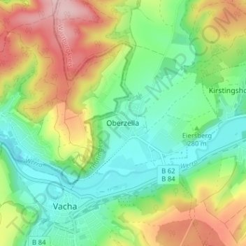
Name: Oberzella topographic map, elevation, terrain.
Location: Oberzella, Vacha, Wartburgkreis, Thüringen, 36404, Deutschland (50.82087 10.01629 50.86087 10.05629)
Average elevation: 296 m
Minimum elevation: 215 m
Maximum elevation: 430 m
Make a donation
Gear up for your next adventure:
As an Amazon Associate, this site earns from qualifying purchases at no extra cost to you.