
Make a donation
Gear up for your next adventure:
As an Amazon Associate, this site earns from qualifying purchases at no extra cost to you.
Colungo topographic map
Click on the map to display elevation.
Make a donation
Gear up for your next adventure:
As an Amazon Associate, this site earns from qualifying purchases at no extra cost to you.
About this map
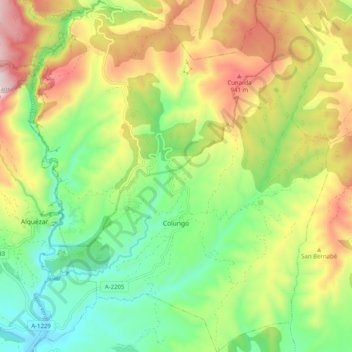
Name: Colungo topographic map, elevation, terrain.
Location: Colungo, Somontano de Barbastro, Huesca, Aragon, Espagne (42.14432 0.02316 42.21875 0.10895)
Average elevation: 701 m
Minimum elevation: 451 m
Maximum elevation: 1,067 m
Make a donation
Gear up for your next adventure:
As an Amazon Associate, this site earns from qualifying purchases at no extra cost to you.
Other topographic maps
Click on a map to view its topography, its elevation and its terrain.
Rodellar
Espagne > Aragon > Somontano de Barbastro > Bierge
Rodellar, à une altitude de 761 m, est situé à 59 km de Huesca, la capitale de la province.
Average elevation: 937 m
Make a donation
Gear up for your next adventure:
As an Amazon Associate, this site earns from qualifying purchases at no extra cost to you.