
Pavuvu topographic map
Interactive map
Click on the map to display elevation.
About this map
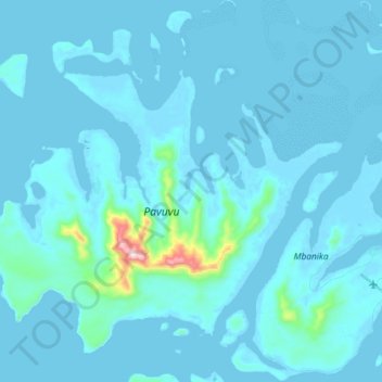
Name: Pavuvu topographic map, elevation, terrain.
Location: Pavuvu, Central Province, Solomon Islands (-9.12500 159.02833 -8.97667 159.20500)
Average elevation: 26 m
Minimum elevation: -4 m
Maximum elevation: 514 m
Other topographic maps
Click on a map to view its topography, its elevation and its terrain.
Mbanika
Solomon Islands > Central Province
Mbanika, Central Province, Solomon Islands
Average elevation: 22 m
Central Province
Solomon Islands > Central Province
Central Province, Solomon Islands
Average elevation: 23 m
Nggela Sule
Solomon Islands > Central Province
Nggela Sule, Central Province, Solomon Islands
Average elevation: 33 m