
Make a donation
Gear up for your next adventure:
As an Amazon Associate, this site earns from qualifying purchases at no extra cost to you.
Zella topographic map
Click on the map to display elevation.
Make a donation
Gear up for your next adventure:
As an Amazon Associate, this site earns from qualifying purchases at no extra cost to you.
About this map
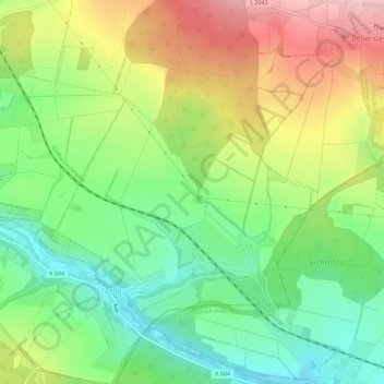
Name: Zella topographic map, elevation, terrain.
Average elevation: 360 m
Minimum elevation: 281 m
Maximum elevation: 468 m
Make a donation
Gear up for your next adventure:
As an Amazon Associate, this site earns from qualifying purchases at no extra cost to you.
Other topographic maps
Click on a map to view its topography, its elevation and its terrain.
Zella
Deutschland > Thüringen > Landkreis Eichsfeld > Dingelstädt
Zella liegt an der Landesstraße 2041 von Dachrieden nach Dingelstädt ungefähr neun Kilometer nordwestlich von Mühlhausen. Die Gemarkung liegt im Unstruttal zwischen den Höhenlagen des Dün im Nordosten, des Oberen Eichsfeldes im Westen und dem Thüringer Becken im Südosten.
Average elevation: 346 m