Geolocate

Oruro topographic map

Click on the map to display elevation.

About this map

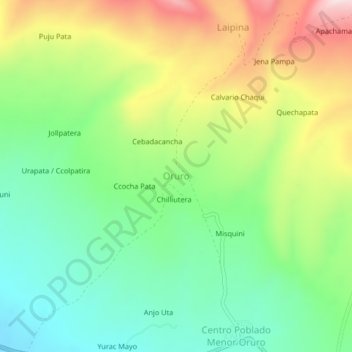
Name: Oruro topographic map, elevation, terrain.

Location: Oruro, Crucero, Province of Carabaya, Puno, Peru (-14.37134 -69.95792 -14.33134 -69.91792)

Average elevation: 4,335 m

Minimum elevation: 4,173 m

Maximum elevation: 4,593 m

Gear up for your next adventure:

🧥Ultralight Puffy Jacket - Maximum warmth that packs down to the size of an orange
🎒Fully Waterproof Backpack - Total protection for photography gear and electronics
🔋Emergency Crank Radio - Weather alerts and power without needing batteries
🧰Survival Kit - Essential gear for emergencies in the wilderness
🧴Bear Spray Holster - Quick-access carry for essential Canadian wilderness safety

As an Amazon Associate, this site earns from qualifying purchases at no extra cost to you.