Geolocate

Pait topographic map

Click on the map to display elevation.

About this map

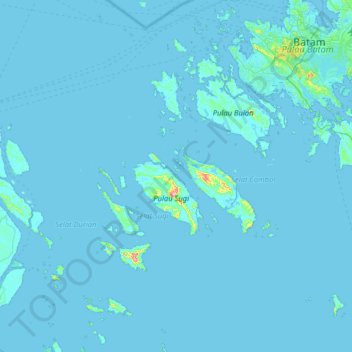
Name: Pait topographic map, elevation, terrain.

Location: Pait, Keban, Karimun, Riau Islands, Sumatra, Indonesia (0.53917 103.47583 1.17917 104.11583)

Average elevation: 4 m

Minimum elevation: -2 m

Maximum elevation: 265 m

Other topographic maps

Click on a map to view its topography, its elevation and its terrain.

Pulau Sugi

Indonesia > Riau Islands > Karimun > Keban

Average elevation: 17 m

Gear up for your next adventure:

🛶Kayak Dry Bag - Waterproof storage for kayaking adventures
🧥Ultralight Puffy Jacket - Maximum warmth that packs down to the size of an orange
🥾Durable Hiking Shoes - Long-lasting shoes for frequent hiking
🏕️Camping Hammock - Integrated protection for sleeping between trees
🥾Approach Boots - Comfortable boots for hiking and climbing approaches

As an Amazon Associate, this site earns from qualifying purchases at no extra cost to you.