
Make a donation
Gear up for your next adventure:
As an Amazon Associate, this site earns from qualifying purchases at no extra cost to you.
Paraíba topographic map
Click on the map to display elevation.
Make a donation
Gear up for your next adventure:
As an Amazon Associate, this site earns from qualifying purchases at no extra cost to you.
Paraíba
Paraíba, located in the eastern portion of the broader Northeast region, is one of 27 states of Brazil. Its total area is 56,467.242 km2, making it the seventh smallest state in the country and the fourth smallest in the Northeast. The distance between its north and south extremities is 263 kilometers, and that of its east and west extremities is 443 kilometers. On average, the state sits at a relatively low elevation, with its highest elevations found in the Borborema Plateau in the center of the state. The highest peak in Paraíba and the third highest peak in the Northeast, Pico do Jabre, is located in this plateau at 1,208 meters above sea level.
Make a donation
Gear up for your next adventure:
As an Amazon Associate, this site earns from qualifying purchases at no extra cost to you.
About this map
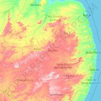
Name: Paraíba topographic map, elevation, terrain.
Location: Paraíba, Northeast Region, Brazil (-8.30296 -38.76560 -6.02591 -34.57535)
Average elevation: 310 m
Minimum elevation: -2 m
Maximum elevation: 1,152 m
Make a donation
Gear up for your next adventure:
As an Amazon Associate, this site earns from qualifying purchases at no extra cost to you.
Other topographic maps
Click on a map to view its topography, its elevation and its terrain.