Geolocate

Sharp Mountain topographic map

Click on the map to display elevation.

About this map

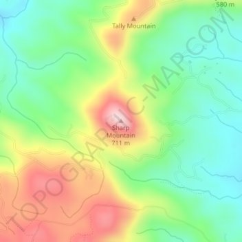
Name: Sharp Mountain topographic map, elevation, terrain.

Location: Sharp Mountain, Pickens County, Georgia, United States (34.43889 -84.50709 34.43899 -84.50699)

Average elevation: 516 m

Minimum elevation: 397 m

Maximum elevation: 697 m

Other topographic maps

Click on a map to view its topography, its elevation and its terrain.

Jasper

United States > Georgia > Pickens County > Jasper

Average elevation: 408 m

Nelson

United States > Georgia > Pickens County

Average elevation: 374 m

Gear up for your next adventure:

🥾Mountain Trail Shoes - High-traction shoes for mountain trails
🥾Trail Hiking Socks - Comfortable socks to prevent blisters and fatigue
🔭Compact Binoculars - Lightweight optics for scouting trails and wildlife
🔦LED Flashlight - Powerful and long-lasting flashlight for camping and emergencies
🥾Trekking Boots - Durable boots for long-distance trekking

As an Amazon Associate, this site earns from qualifying purchases at no extra cost to you.