
Make a donation
Gear up for your next adventure:
As an Amazon Associate, this site earns from qualifying purchases at no extra cost to you.
Pyrbaum topographic map
Click on the map to display elevation.
Make a donation
Gear up for your next adventure:
As an Amazon Associate, this site earns from qualifying purchases at no extra cost to you.
Pyrbaum
Als westlichste Gemeinde des Regierungsbezirks der Oberpfalz liegt Pyrbaum 20 km südöstlich der Stadt Nürnberg. Sein Gebiet ist größtenteils von Wald bedeckt. Als einzige Gemeinde der Oberpfalz gehört Pyrbaum zur Region Franken. Der Ort liegt auf einer gerodeten Anhöhe. Der Gemeindeteil Neumühle ist der westlichste Punkt der Oberpfalz.
Make a donation
Gear up for your next adventure:
As an Amazon Associate, this site earns from qualifying purchases at no extra cost to you.
About this map
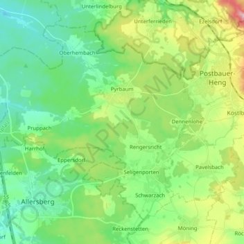
Name: Pyrbaum topographic map, elevation, terrain.
Average elevation: 424 m
Minimum elevation: 363 m
Maximum elevation: 568 m
Make a donation
Gear up for your next adventure:
As an Amazon Associate, this site earns from qualifying purchases at no extra cost to you.