
Make a donation
Gear up for your next adventure:
As an Amazon Associate, this site earns from qualifying purchases at no extra cost to you.
Penman topographic map
Click on the map to display elevation.
Make a donation
Gear up for your next adventure:
As an Amazon Associate, this site earns from qualifying purchases at no extra cost to you.
About this map
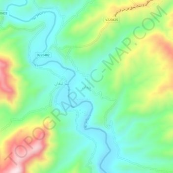
Name: Penman topographic map, elevation, terrain.
Location: Penman, Kiti, Daykundi Province, Afghanistan (33.49276 65.66391 33.53276 65.70391)
Average elevation: 1,557 m
Minimum elevation: 1,404 m
Maximum elevation: 1,879 m
Make a donation
Gear up for your next adventure:
As an Amazon Associate, this site earns from qualifying purchases at no extra cost to you.
Other topographic maps
Click on a map to view its topography, its elevation and its terrain.
Kiti
Afghanistan > Daykundi Province
Kiti or Keti (Persian: کیتی), is a district in Daykundi province in central Afghanistan. It was created in 2005 from the former Kajran district. The main village Kiti is at 1,783 m altitude.
Average elevation: 2,365 m
Kiti
Afghanistan > Daykundi Province
Kiti or Keti (Persian: کیتی), is a district in Daykundi province in central Afghanistan. It was created in 2005 from the former Kajran district. The main village Kiti is at 1,783 m altitude.
Average elevation: 2,365 m