Geolocate

Abellá topographic map

Click on the map to display elevation.

About this map

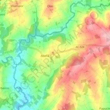
Name: Abellá topographic map, elevation, terrain.

Location: Abellá, Frades, Ordes, La Coruña, Galicia, España (43.06580 -8.33864 43.09911 -8.26750)

Average elevation: 356 m

Minimum elevation: 285 m

Maximum elevation: 441 m

Gear up for your next adventure:

💡LED Camping Lantern - Illuminate your campsite with long-lasting lanterns
🧥Ultralight Puffy Jacket - Maximum warmth that packs down to the size of an orange
🧢Sun Protection Cap - Breathable cap to protect from sun exposure
🌡️Emergency Mylar Blankets - Compact thermal protection for unexpected nights outdoors
🧥Softshell Hiking Jacket - The perfect balance of wind protection and breathability

As an Amazon Associate, this site earns from qualifying purchases at no extra cost to you.