
Camajuaní topographic map
Interactive map
Click on the map to display elevation.
About this map
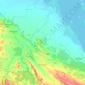
Name: Camajuaní topographic map, elevation, terrain.
Location: Camajuaní, Villa Clara, Cuba (22.37558 -79.83120 22.76144 -79.58603)
Average elevation: 48 m
Minimum elevation: -2 m
Maximum elevation: 263 m
Other topographic maps
Click on a map to view its topography, its elevation and its terrain.
Esperanza
Cuba > Villa Clara > Esperanza
Esperanza, Ranchuelo, Villa Clara, 54540, Cuba
Average elevation: 91 m