
Make a donation
Gear up for your next adventure:
As an Amazon Associate, this site earns from qualifying purchases at no extra cost to you.
Bad Rothenfelde topographic map
Click on the map to display elevation.
Make a donation
Gear up for your next adventure:
As an Amazon Associate, this site earns from qualifying purchases at no extra cost to you.
About this map
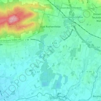
Name: Bad Rothenfelde topographic map, elevation, terrain.
Average elevation: 101 m
Minimum elevation: 73 m
Maximum elevation: 211 m
Make a donation
Gear up for your next adventure:
As an Amazon Associate, this site earns from qualifying purchases at no extra cost to you.
Other topographic maps
Click on a map to view its topography, its elevation and its terrain.
Make a donation
Gear up for your next adventure:
As an Amazon Associate, this site earns from qualifying purchases at no extra cost to you.
Bad Essen
Germany > Lower Saxony > Landkreis Osnabrück > Bad Essen > Bad Essen
Average elevation: 85 m
Fürstenau
Germany > Lower Saxony > Landkreis Osnabrück > Fürstenau > Fürstenau
Average elevation: 54 m
Schwagstorf
Germany > Lower Saxony > Landkreis Osnabrück > Fürstenau > Schwagstorf
Average elevation: 84 m
Make a donation
Gear up for your next adventure:
As an Amazon Associate, this site earns from qualifying purchases at no extra cost to you.