Geolocate

Ribchester topographic map

Click on the map to display elevation.

About this map

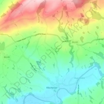
Name: Ribchester topographic map, elevation, terrain.

Location: Ribchester, Ribble Valley, Lancashire, England, United Kingdom (53.80401 -2.57577 53.85540 -2.51515)

Average elevation: 111 m

Minimum elevation: 21 m

Maximum elevation: 282 m

Gear up for your next adventure:

🧦Thermal Socks - Warm socks for winter hiking or camping
🪑Insulated Seat Pad - Protect your seat from cold rocks and wet logs
🚲MTB Frame Bag - Carry tools and maps directly on your bicycle frame
🧥Waterproof Pants - Keep dry during rainy hiking conditions
🧳Compression Sacks - Maximize space in your backpack by shrinking gear

As an Amazon Associate, this site earns from qualifying purchases at no extra cost to you.