
Make a donation
Gear up for your next adventure:
As an Amazon Associate, this site earns from qualifying purchases at no extra cost to you.
Auch topographic map
Click on the map to display elevation.
Make a donation
Gear up for your next adventure:
As an Amazon Associate, this site earns from qualifying purchases at no extra cost to you.
Auch
Auch has a minimum altitude of 115 metres (377 ft) and a maximum of 281 metres (922 ft). Its average altitude is 198 metres (650 ft), while that of its town hall is 134 metres (440 ft) The town and its surroundings have a hillside landscape.
Make a donation
Gear up for your next adventure:
As an Amazon Associate, this site earns from qualifying purchases at no extra cost to you.
About this map
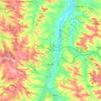
Name: Auch topographic map, elevation, terrain.
Location: Auch, Gers, Occitania, Metropolitan France, 32000, France (43.61719 0.48604 43.70772 0.64709)
Average elevation: 190 m
Minimum elevation: 114 m
Maximum elevation: 284 m
Make a donation
Gear up for your next adventure:
As an Amazon Associate, this site earns from qualifying purchases at no extra cost to you.