
Make a donation
Gear up for your next adventure:
As an Amazon Associate, this site earns from qualifying purchases at no extra cost to you.
Sonogno topographic map
Click on the map to display elevation.
Make a donation
Gear up for your next adventure:
As an Amazon Associate, this site earns from qualifying purchases at no extra cost to you.
Sonogno
The village is located in the Locarno district, Sonogno is the last village on the paved road through the Valley Verzasca. All motor vehicles are required to park at the entrance to the village. It is located at an elevation of 918 m (3,012 ft) about 30 km (19 mi) from Locarno.
Make a donation
Gear up for your next adventure:
As an Amazon Associate, this site earns from qualifying purchases at no extra cost to you.
About this map
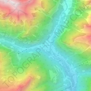
Name: Sonogno topographic map, elevation, terrain.
Average elevation: 1,434 m
Minimum elevation: 842 m
Maximum elevation: 2,513 m
Make a donation
Gear up for your next adventure:
As an Amazon Associate, this site earns from qualifying purchases at no extra cost to you.