
Make a donation
Gear up for your next adventure:
As an Amazon Associate, this site earns from qualifying purchases at no extra cost to you.
Walhain topographic map
Click on the map to display elevation.
Make a donation
Gear up for your next adventure:
As an Amazon Associate, this site earns from qualifying purchases at no extra cost to you.
Walhain
Walhain (en wallon « Walin ». Origine (Xe s.) : « Walaham ». Ce toponyme se divise en deux parties : Wahl - Walo Wallo —, qui est le nom d'un homme d'origine germanique, et Hain, transposition romaine du germanique « Hein » qui signifie village) est une commune francophone de Belgique située en Région wallonne dans la Province du Brabant wallon. Elle regroupe les villages de Nil Saint-Vincent-Saint-Martin (altitude +/- 100m), Tourinnes-Saint-Lambert (+/- 130m) et Walhain-Saint-Paul (+/-120m).
Make a donation
Gear up for your next adventure:
As an Amazon Associate, this site earns from qualifying purchases at no extra cost to you.
About this map
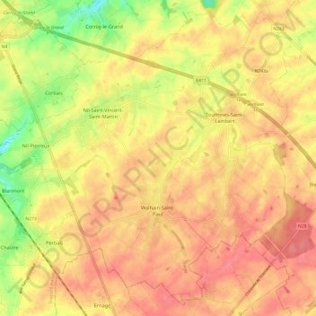
Name: Walhain topographic map, elevation, terrain.
Location: Walhain, Nivelles, Brabant wallon, Wallonie, 1457, Belgique (50.59424 4.62594 50.66535 4.74640)
Average elevation: 149 m
Minimum elevation: 106 m
Maximum elevation: 171 m
Make a donation
Gear up for your next adventure:
As an Amazon Associate, this site earns from qualifying purchases at no extra cost to you.
Other topographic maps
Click on a map to view its topography, its elevation and its terrain.
Make a donation
Gear up for your next adventure:
As an Amazon Associate, this site earns from qualifying purchases at no extra cost to you.
Make a donation
Gear up for your next adventure:
As an Amazon Associate, this site earns from qualifying purchases at no extra cost to you.
Make a donation
Gear up for your next adventure:
As an Amazon Associate, this site earns from qualifying purchases at no extra cost to you.
Make a donation
Gear up for your next adventure:
As an Amazon Associate, this site earns from qualifying purchases at no extra cost to you.
Grand-Rosière-Hottomont
Belgique > Brabant wallon > Nivelles > Grand-Rosière-Hottomont
Average elevation: 142 m
Malaise
Belgique > Brabant wallon > Nivelles > Ottignies-Louvain-la-Neuve > Ottignies
Average elevation: 108 m
Make a donation
Gear up for your next adventure:
As an Amazon Associate, this site earns from qualifying purchases at no extra cost to you.
Château d'Hélécine
Belgique > Brabant wallon > Nivelles > Opheylissem > Hampteau
Average elevation: 65 m
Make a donation
Gear up for your next adventure:
As an Amazon Associate, this site earns from qualifying purchases at no extra cost to you.