Geolocate

Natatas topographic map

Click on the map to display elevation.

About this map
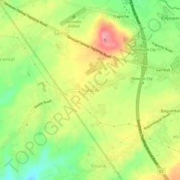
Name: Natatas topographic map, elevation, terrain.

Location: Natatas, Tanauan, Batangas, Calabarzon, 4232, Philippines (14.06086 121.10006 14.10086 121.14006)

Average elevation: 150 m

Minimum elevation: 99 m

Maximum elevation: 202 m

Other topographic maps

Click on a map to view its topography, its elevation and its terrain.

Talaga

Philippines > Batangas > Tanauan > Talaga

Average elevation: 135 m

Maria Paz

Philippines > Batangas > Tanauan

Average elevation: 64 m

Barangay 3

Philippines > Batangas > Tanauan > Hidalgo

Average elevation: 158 m

Barangay 5

Philippines > Batangas > Tanauan > Hidalgo

Average elevation: 154 m

Suplang

Philippines > Batangas > Tanauan

Average elevation: 247 m

Ambulong

Philippines > Batangas > Tanauan > Maugat

Average elevation: 28 m

Barangay 4

Philippines > Batangas > Tanauan

Average elevation: 142 m

Darasa

Philippines > Batangas > Tanauan > Hidalgo

Average elevation: 173 m

Laurel

Philippines > Batangas > Tanauan

Average elevation: 153 m

Banjo West

Philippines > Batangas > Tanauan > Banjo Laurel

Average elevation: 155 m

Darasa

Philippines > Batangas > Tanauan > Hidalgo

Average elevation: 173 m

Ulango

Philippines > Batangas > Tanauan

Average elevation: 145 m

Bañadero

Philippines > Batangas > Tanauan > Bañadero

Average elevation: 58 m

Barangay 5

Philippines > Batangas > Tanauan > Hidalgo

Average elevation: 154 m

Gear up for your next adventure:

💡Portable Camping Lamp - Rechargeable lamp for campsite lighting
🔭Compact Binoculars - Lightweight optics for scouting trails and wildlife
🧤Rechargeable Heated Gloves - Extreme warmth for Canadian winter expeditions
🧦Hiking Socks - Moisture-wicking and comfortable socks for long hikes
⛺Camping Groundsheet - Protect your tent from moisture and dirt

As an Amazon Associate, this site earns from qualifying purchases at no extra cost to you.