
Thank you for supporting this site ❤️
Make a donation
Make a donation
Gear up for your next adventure:
As an Amazon Associate, this site earns from qualifying purchases at no extra cost to you.
Col d'Azet topographic map
Click on the map to display elevation.
Thank you for supporting this site ❤️
Make a donation
Make a donation
Gear up for your next adventure:
As an Amazon Associate, this site earns from qualifying purchases at no extra cost to you.
Col d'Azet
De Col de Val-Louron-Azet is een 1580 meter hoge bergpas in de Pyreneeën. De bergpas overbrugt een hoogteverschil van 610 m en heeft een gemiddeld stijgingspercentage van 8,5%.
Thank you for supporting this site ❤️
Make a donation
Make a donation
Gear up for your next adventure:
As an Amazon Associate, this site earns from qualifying purchases at no extra cost to you.
About this map
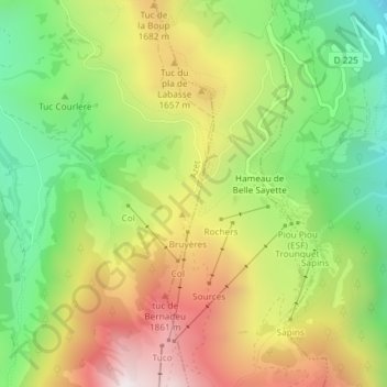
Name: Col d'Azet topographic map, elevation, terrain.
Average elevation: 1,485 m
Minimum elevation: 1,046 m
Maximum elevation: 2,016 m
Thank you for supporting this site ❤️
Make a donation
Make a donation
Gear up for your next adventure:
As an Amazon Associate, this site earns from qualifying purchases at no extra cost to you.