
Make a donation
Gear up for your next adventure:
As an Amazon Associate, this site earns from qualifying purchases at no extra cost to you.
Spring Mill topographic map
Click on the map to display elevation.
Make a donation
Gear up for your next adventure:
As an Amazon Associate, this site earns from qualifying purchases at no extra cost to you.
About this map
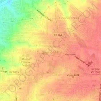
Name: Spring Mill topographic map, elevation, terrain.
Location: Spring Mill, Jefferson County, Kentucky, United States (38.14215 -85.63560 38.14552 -85.62722)
Average elevation: 195 m
Minimum elevation: 148 m
Maximum elevation: 213 m
Make a donation
Gear up for your next adventure:
As an Amazon Associate, this site earns from qualifying purchases at no extra cost to you.
Other topographic maps
Click on a map to view its topography, its elevation and its terrain.
Jefferson Memorial Forest
United States > Kentucky > Jefferson County > Louisville
Average elevation: 164 m
Louisville-Jefferson County (Balance)
United States > Kentucky > Jefferson County > Louisville
Average elevation: 157 m
Make a donation
Gear up for your next adventure:
As an Amazon Associate, this site earns from qualifying purchases at no extra cost to you.
Make a donation
Gear up for your next adventure:
As an Amazon Associate, this site earns from qualifying purchases at no extra cost to you.
Falls of the Ohio State Park
United States > Kentucky > Jefferson County > Louisville
Average elevation: 135 m
Bellewood
United States > Kentucky > Jefferson County > St. Matthews > Bellewood
Average elevation: 167 m