
Make a donation
Gear up for your next adventure:
As an Amazon Associate, this site earns from qualifying purchases at no extra cost to you.
Mount Lyford topographic map
Click on the map to display elevation.
Make a donation
Gear up for your next adventure:
As an Amazon Associate, this site earns from qualifying purchases at no extra cost to you.
Mount Lyford
In addition to the subdivision a commercial ski field and access road was developed in the overlooking mountains catering for families, including ice-skating, day shelter/cafeteria together with ski tows and car parking. Currently the Simpson family continues to operate Mt Lyford Alpine Resort ski field. Following a run of several years of disappointing snowfall the resort moved higher up the mountain and expanded. Its higher elevation makes snowfall more predictable and the ski resort now includes access to Mt Terako (1742 m) and caters for beginner, intermediate and advanced skiers and snowboarders. The runs cover an elevation range of 1249 m to 1740 m. There is one T-bar, one poma lift, two "platters", one rope tow, and one "advanced rope tow". Most trails are groomed and there is a snowboard board with half pipe and "fun box".
Make a donation
Gear up for your next adventure:
As an Amazon Associate, this site earns from qualifying purchases at no extra cost to you.
About this map
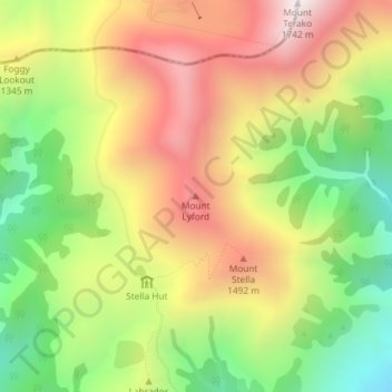
Name: Mount Lyford topographic map, elevation, terrain.
Location: Mount Lyford, Hurunui District, New Zealand (-42.46047 173.14398 -42.46037 173.14408)
Average elevation: 1,242 m
Minimum elevation: 755 m
Maximum elevation: 1,745 m
Make a donation
Gear up for your next adventure:
As an Amazon Associate, this site earns from qualifying purchases at no extra cost to you.
Other topographic maps
Click on a map to view its topography, its elevation and its terrain.