Geolocate

Ligaya topographic map

Click on the map to display elevation.

About this map

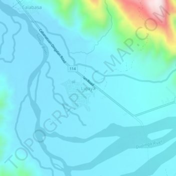
Name: Ligaya topographic map, elevation, terrain.

Location: Ligaya, Gabaldon, Nueva Ecija, Central Luzon, Philippines (15.48978 121.26704 15.52978 121.30704)

Average elevation: 152 m

Minimum elevation: 93 m

Maximum elevation: 683 m

Other topographic maps

Click on a map to view its topography, its elevation and its terrain.

Dupinga River

Philippines > Nueva Ecija > Gabaldon

Average elevation: 650 m

Gear up for your next adventure:

🥤Collapsible Travel Cup - Saves space and weight in your mess kit
💧Hydration Pack - Hands-free hydration system for long hikes
🥫Freeze-Dried Meals - Lightweight, high-calorie nutrition for multi-day treks
🧊Insulated Water Bottle - Keeps drinks cold in summer and prevents freezing in winter
🧥Waterproof Hiking Jacket - Protect yourself from rain and wind while hiking

As an Amazon Associate, this site earns from qualifying purchases at no extra cost to you.