
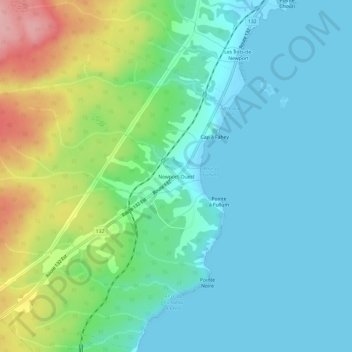
Newport-Ouest topographic map
Interactive map
Click on the map to display elevation.
About this map
Name: Newport-Ouest topographic map, elevation, terrain.
Average elevation: 38 m
Minimum elevation: -1 m
Maximum elevation: 145 m
Other topographic maps
Click on a map to view its topography, its elevation and its terrain.
Saint-François-de-Pabos
Canada > Quebec > Le Rocher-Percé > Chandler
Saint-François-de-Pabos, Chandler, Le Rocher-Percé, Gaspésie–Îles-de-la-Madeleine, Quebec, G0C 2H0, Canada
Average elevation: 41 m
Lac des Îles
Canada > Quebec > Le Rocher-Percé > Chandler
Lac des Îles, Chandler, Le Rocher-Percé, Gaspésie–Îles-de-la-Madeleine, Quebec, Canada
Average elevation: 119 m
Île Beau Séjour
Canada > Quebec > Le Rocher-Percé > Chandler
Île Beau Séjour, Chandler, Le Rocher-Percé, Gaspésie–Îles-de-la-Madeleine, Quebec, Canada
Average elevation: 2 m
Pabos
Canada > Quebec > Le Rocher-Percé > Chandler
Pabos, Chandler, Le Rocher-Percé, Gaspésie–Îles-de-la-Madeleine, Quebec, G0C 2H0, Canada
Average elevation: 9 m