Geolocate

Neira topographic map

Click on the map to display elevation.

About this map

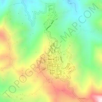
Name: Neira topographic map, elevation, terrain.

Location: Neira, Centrosur, Caldas, 171001, Colombia (5.16110 -75.52524 5.17806 -75.51442)

Average elevation: 1,870 m

Minimum elevation: 1,610 m

Maximum elevation: 2,199 m

Gear up for your next adventure:

🪑Ultralight Camping Stool - Compact seating for rest stops during long hikes
🥾Mountain Hiking Shoes - Shoes with superior grip for mountainous terrain
💡LED Headlamp - Hands-free illumination for night hiking and camping
🥾Hiking Shorts - Breathable shorts suitable for summer hikes
🏃Hydration Running Vest - Carry water and maps close to your body for speed

As an Amazon Associate, this site earns from qualifying purchases at no extra cost to you.