Geolocate

Lourido topographic map

Click on the map to display elevation.

About this map

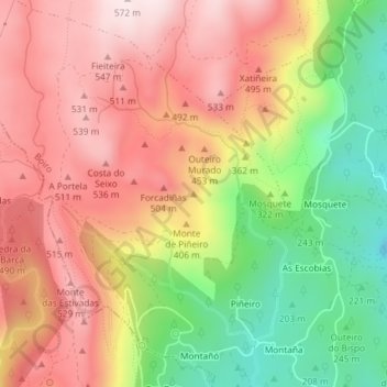
Name: Lourido topographic map, elevation, terrain.

Location: Lourido, Boiro, Barbanza, La Coruña, Galicia, 15992, España (42.66146 -8.92911 42.66156 -8.92901)

Average elevation: 365 m

Minimum elevation: 112 m

Maximum elevation: 565 m

Gear up for your next adventure:

🧢Beanie Hat - Keep your head warm in cold weather
🔦UV Flashlight - Detect minerals or specific insects in the dark
👟Sport Hiking Sandals - Breathable footwear for water crossings and camp rest
🕯️Camping Lantern - Illuminates your entire campsite with high-efficiency LEDs
🩹Moleskin Blister Pads - Direct protection for painful foot pressure points

As an Amazon Associate, this site earns from qualifying purchases at no extra cost to you.