Geolocate

Thorp topographic map

Click on the map to display elevation.

About this map

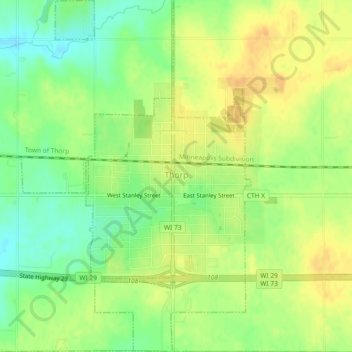
Name: Thorp topographic map, elevation, terrain.

Location: Thorp, Clark County, Wisconsin, United States (44.94470 -90.82011 44.97715 -90.79017)

Average elevation: 369 m

Minimum elevation: 351 m

Maximum elevation: 383 m

Gear up for your next adventure:

🥾Lightweight Hiking Boots - Boots for comfort and mobility on long hikes
🧦Hiking Socks - Moisture-wicking and comfortable socks for long hikes
🥾Durable Hiking Shoes - Long-lasting shoes for frequent hiking
🛶Kayak Accessories - Essential gear for safe and fun kayaking adventures
🥾Approach Shoes - Shoes designed for climbing approaches and rugged trails

As an Amazon Associate, this site earns from qualifying purchases at no extra cost to you.