Geolocate

Batee topographic map

Click on the map to display elevation.

About this map

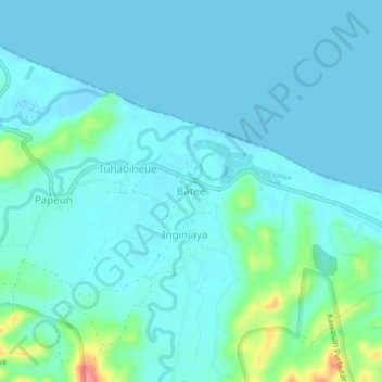
Name: Batee topographic map, elevation, terrain.

Location: Batee, Muara Tiga, Pidie, Aceh, Sumatra, Indonesia (5.51571 95.77928 5.55571 95.81928)

Average elevation: 13 m

Minimum elevation: -1 m

Maximum elevation: 90 m

Other topographic maps

Click on a map to view its topography, its elevation and its terrain.

Sakti

Indonesia > Aceh > Pidie

Average elevation: 39 m

Simpang Tiga

Indonesia > Aceh > Pidie

Average elevation: 5 m

Geumpang

Indonesia > Aceh > Pidie

Average elevation: 1,196 m

Sakti

Indonesia > Aceh > Pidie

Average elevation: 39 m

Gear up for your next adventure:

🧢Outdoor Visor - Breathable visor for sunny hikes
🪜Heavy Duty Carabiners - Multi-use clips for securing gear to your backpack
🥾Hiking Gaiters - Protect legs and shoes from mud, snow, and debris
🔦LED Headlamp - Hands-free lighting for early morning starts or late finishes
🧰Survival Kit - Essential gear for emergencies in the wilderness

As an Amazon Associate, this site earns from qualifying purchases at no extra cost to you.