Geolocate

Bato topographic map

Click on the map to display elevation.

About this map

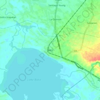
Name: Bato topographic map, elevation, terrain.

Location: Bato, Camarines Sur, Bicol Region, 4435, Philippines (13.31725 123.32774 13.39725 123.40774)

Average elevation: 13 m

Minimum elevation: 2 m

Maximum elevation: 54 m

Gear up for your next adventure:

🛰️Satellite Messenger - Emergency communication for areas with no cell service
🥽Outdoor Goggles - Protective eyewear for outdoor activities
🩹Compact First Aid Kit - Pre-packed essentials for common trail injuries
🧦Outdoor Socks - Durable socks designed for hiking and outdoor sports
🥾Trail Hiking Socks - Comfortable socks to prevent blisters and fatigue

As an Amazon Associate, this site earns from qualifying purchases at no extra cost to you.