Geolocate

Broby topographic map

Click on the map to display elevation.

About this map

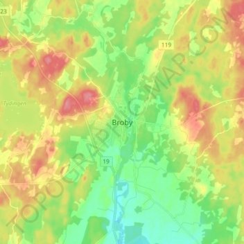
Name: Broby topographic map, elevation, terrain.

Location: Broby, Östra Göinge kommun, Skåne County, 289 42, Sweden (56.21493 14.03772 56.29493 14.11772)

Average elevation: 54 m

Minimum elevation: 20 m

Maximum elevation: 97 m

Other topographic maps

Click on a map to view its topography, its elevation and its terrain.

Vellinge kommun

Sweden > Skåne County

Average elevation: 8 m

Klippans kommun

Sweden > Skåne County

Average elevation: 75 m

Simrishamns kommun

Sweden > Skåne County

Average elevation: 28 m

Lea

Sweden > Skåne County > Malmo

Average elevation: 8 m

Båstads kommun

Sweden > Skåne County

Average elevation: 36 m

Ystads kommun

Sweden > Skåne County

Average elevation: 22 m

Gear up for your next adventure:

🧢Outdoor Cap - Protective cap for sun and rain during hikes
🧦Hiking Socks - Moisture-wicking and comfortable socks for long hikes
Camping Tent - Weather-resistant tents suitable for 2 to 6 people
🔪Outdoor Multitool - Versatile tool for repairs and food prep in the wild
Family Camping Tent - Spacious tent suitable for family camping trips

As an Amazon Associate, this site earns from qualifying purchases at no extra cost to you.