
Crediton topographic map
Click on the map to display elevation.
About this map
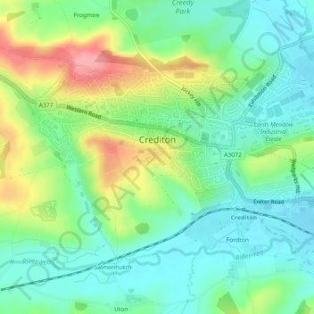
Name: Crediton topographic map, elevation, terrain.
Location: Crediton, Mid Devon, Devon, England, United Kingdom (50.77753 -3.67628 50.79845 -3.63192)
Average elevation: 71 m
Minimum elevation: 36 m
Maximum elevation: 142 m
Other topographic maps
Click on a map to view its topography, its elevation and its terrain.
White Cross
United Kingdom > England > Devon > Mid Devon > Cheriton Fitzpaine
Average elevation: 131 m
Bailey
United Kingdom > England > Devon > Mid Devon > Newton St. Cyres > Bailey
Average elevation: 91 m