
Make a donation
Gear up for your next adventure:
As an Amazon Associate, this site earns from qualifying purchases at no extra cost to you.
Jimena de la Frontera topographic map
Click on the map to display elevation.
Make a donation
Gear up for your next adventure:
As an Amazon Associate, this site earns from qualifying purchases at no extra cost to you.
Jimena de la Frontera
Jimena de la Frontera enjoys a moderate Mediterranean climate. There are 3,000 hours of sunshine per year, which contributes to average temperatures of between 18 and 20 °C (64 and 68 °F). However, the rainfall pattern differs significantly from the rest of southern Spain, due to the topography of the Strait of Gibraltar region, which is swept by east and west winds that bring humidity and, therefore, rainfall averaging 900 to 1,000 mm (35 to 39 in).
Make a donation
Gear up for your next adventure:
As an Amazon Associate, this site earns from qualifying purchases at no extra cost to you.
About this map
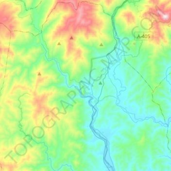
Name: Jimena de la Frontera topographic map, elevation, terrain.
Average elevation: 269 m
Minimum elevation: 14 m
Maximum elevation: 1,001 m
Make a donation
Gear up for your next adventure:
As an Amazon Associate, this site earns from qualifying purchases at no extra cost to you.
Other topographic maps
Click on a map to view its topography, its elevation and its terrain.
Castillo de Castellar
Spain > Andalusia > Campo de Gibraltar > Castellar de la Frontera > Castellar Viejo de la Frontera
Average elevation: 102 m
Make a donation
Gear up for your next adventure:
As an Amazon Associate, this site earns from qualifying purchases at no extra cost to you.