Geolocate

Abtwil topographic map

Click on the map to display elevation.

About this map

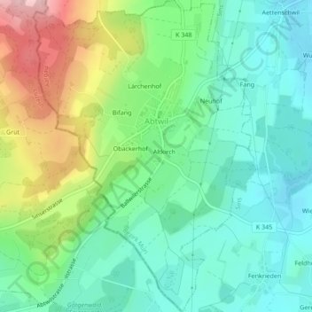
Name: Abtwil topographic map, elevation, terrain.

Location: Abtwil, Bezirk Muri, Aargau, 5646, Switzerland (47.15674 8.33792 47.18561 8.36762)

Average elevation: 539 m

Minimum elevation: 479 m

Maximum elevation: 667 m

Other topographic maps

Click on a map to view its topography, its elevation and its terrain.

Benzenschwil

Switzerland > Aargau > Bezirk Muri

Average elevation: 472 m

Gear up for your next adventure:

🦟Insect Repellent - Keep mosquitoes and black flies away in wooded areas
🧥Thermal Layer - Insulating layer for cold outdoor conditions
🧥Waterproof Jacket - Lightweight rain jackets for hiking and outdoor activities
🪑Insulated Seat Pad - Protect your seat from cold rocks and wet logs
🧢Sun Protection Cap - Breathable cap to protect from sun exposure

As an Amazon Associate, this site earns from qualifying purchases at no extra cost to you.