Geolocate

Torremolinos topographic map

Click on the map to display elevation.

About this map

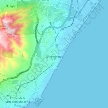
Name: Torremolinos topographic map, elevation, terrain.

Location: Torremolinos, Costa del Sol Occidental, Malaga, Andalusia, Spain (36.59938 -4.56152 36.65240 -4.47522)

Average elevation: 85 m

Minimum elevation: -4 m

Maximum elevation: 598 m

Other topographic maps

Click on a map to view its topography, its elevation and its terrain.

Madrid

Spain > Andalusia > Costa del Sol Occidental > Casares

Average elevation: 737 m

Chaparral

Spain > Andalusia > Costa del Sol Occidental

Average elevation: 29 m

Mijas Golf

Spain > Andalusia > Costa del Sol Occidental

Average elevation: 58 m

Artola

Spain > Andalusia > Costa del Sol Occidental > Marbella

Average elevation: 55 m

Entrerríos

Spain > Andalusia > Costa del Sol Occidental

Average elevation: 121 m

Bel-Air

Spain > Andalusia > Costa del Sol Occidental > Estepona

Average elevation: 35 m

Rícmar

Spain > Andalusia > Costa del Sol Occidental > Marbella

Average elevation: 35 m

La Concha

Spain > Andalusia > Costa del Sol Occidental > Marbella

Average elevation: 784 m

Gear up for your next adventure:

🥾Lightweight Hiking Boots - Boots for comfort and mobility on long hikes
📷Outdoor Action Camera - Capture high-elevation views and rugged adventures
🔥Emergency Fire Starter - Reliable ignition source for all weather conditions
🧢Hiking Sun Hat - Wide-brimmed protection for exposed mountain ridges
🧴Outdoor Sunscreen - High SPF protection for high-altitude UV exposure

As an Amazon Associate, this site earns from qualifying purchases at no extra cost to you.