
Make a donation
Gear up for your next adventure:
As an Amazon Associate, this site earns from qualifying purchases at no extra cost to you.
Wildenloh topographic map
Click on the map to display elevation.
Make a donation
Gear up for your next adventure:
As an Amazon Associate, this site earns from qualifying purchases at no extra cost to you.
Wildenloh
Namensgebend für den Ort ist der gleichnamige Staatsforst Wildenloh, an dessen Nordostrand sich die Siedlung befindet. Dieser ist vermutlich der Rest eines weitläufigen Waldgebietes, das sich einst von Oldenburg bis über Friedrichsfehn und Klein-Scharrel hinaus erstreckte und vor gut 8000 Jahren im sich ausbreitenden Wildenlohs Moor versank. Reste dieses Waldgebietes sind der heutige „Große Wildenloh“ und der „Kleine Wildenloh“, da sie als trockenere Geestinseln der Eversterner Geest mit einer Höhe von etwa 15 m über NN aus dem umgebenden Wildenlohs Moor herausragen.
Make a donation
Gear up for your next adventure:
As an Amazon Associate, this site earns from qualifying purchases at no extra cost to you.
About this map
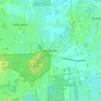
Name: Wildenloh topographic map, elevation, terrain.
Average elevation: 7 m
Minimum elevation: 2 m
Maximum elevation: 16 m
Make a donation
Gear up for your next adventure:
As an Amazon Associate, this site earns from qualifying purchases at no extra cost to you.
Other topographic maps
Click on a map to view its topography, its elevation and its terrain.
26188
Deutschland > Niedersachsen > Landkreis Ammerland > Edewecht > Jeddeloh I
Average elevation: 8 m